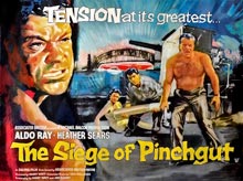
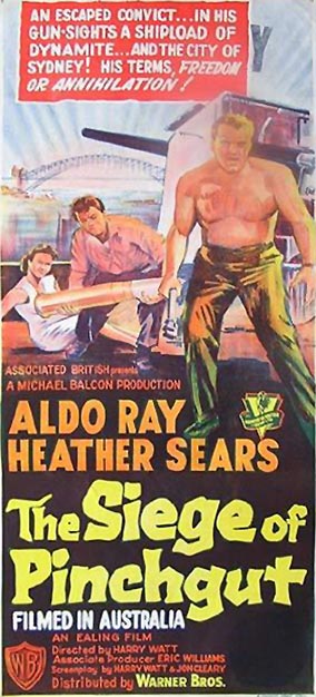
In 1959 a movie was made called The Siege of Pinchgut. Much of the filming took place on a small, island fort in the middle of Sydney Harbour.
In the first few months of arrival in 1788, this island was briefly used to confine and punish wayward convicts. While there they had their rations limited to just bread and water. This explains the origin of the name Pinchgut when commonly referring to this small, rocky island.
The need for greater fortification of the settlement resulted in a fort being eventually completed in the 1850s on the island. It was named Fort Denison after the then governor of the colony.
The end of the 1950s was a time of imminent change. The Opera House was soon to begin construction on Bennelong Point. For those of us who lived on the northern shores of the Harbour, our suburb was about to be ripped apart by the building of the Warringah Expressway. So this modest, little thriller has a significant historic value in documenting parts of Sydney before these changes took place. There is an obvious irony to this since the film has at the core of its narrative a terror threat of great destruction to Sydney.
The movie begins as we follow an ambulance from North Sydney to the Harbour Bridge.
The ambulance moves along Bent Street, overlooking Forsyth Park. It then turns into Alfred Street North where it is stopped by a police road-block. Views of Alfred Street steeply ascending on a higher level are seen above this street. This was the way I walked to school each day from High Street. It took me up to St Leonards Park which I then crossed to reach North Sydney Boys High in the 1960s.
We next see the ambulance entering the Pacific Highway from Walker Street. A clear view is captured of the MLC building showing how it dominated the skyline in those days. Its weather beacon is clearly visible with no obstruction from any other buildings.
The way the ambulance in the film has travelled was not a direct route to the bridge from where it was stopped. Instead of continuing along Alfred Street and thereby arriving directly at the Bridge’s northern entrance, the ambulance has gone back up Mount Street before turning into Walker Street. I am so glad this way was chosen since great shots are seen of the buildings on both sides of the Pacific Highway’s approach to the Bridge. Memories rushed back on seeing these long demolished shops and businesses that were the familiar streetscape of my childhood. I was again reminded of the smell of the motor oil and grease that wafted from the car repair shop on the highway. As if on request, the camera pans across and back up the highway and we catch a glimpse of the Post Office tower at Victoria Cross and North Sydney Technical School to the left. The Orpheum Theatre and the adjacent corner milk bar are seen clearly when a police motor bike again stops the ambulance in front of these buildings. I regularly attended the theatre and milk bar on a Saturday afternoon. I saw the last film screened at the Orpheum. Appropriately it was the epic Gone With The Wind.
The policeman then directs the ambulance across Alfred Street, before stopping it at the top of McDougal Street. Wonderful views of Frank Delandro’s Garage are seen. Our last two family cars were purchased and serviced there. We also get to see again the old northern approach to the Bridge, including the overhead arch that carried the trams and then cars.
All these scenes have been erased from the landscape since 1959. They only survive in memory, art works, photographs and films like this one. which have captured the places of my childhood that no longer exist.
The Siege of Pinchgut also inadvertently captures other parts of Sydney that have changed or are no longer. The Fort Macquarie Tram Depot on Bennelong Point is one of the places included. It was demolished in 1959, the year of the film’s release, to make way for the construction of the Opera House. Included also are some of the steep roads, like Northcliff Street, near Luna Park and various shots of the Harbour foreshores. In one scene where the lead detective tries to communicate from a boat with those on Fort Denison, I could make out Careening Cove, Neutral Bay and a rather blurred High Street wharf.
When this film first came out I was just completing primary school. I imagine its PG content would have stopped my parents from allowing me to see it. It was not until the 1970s that it turned up on television. I do not remember the North Sydney footage that was background to the opening scenes. But to be honest I do not remember much about any of the film. Watching the film on DVD earlier this year was therefore a delightful discovery and surprise for me, awakening many childhood memories.
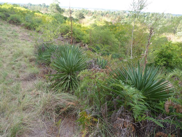
Scattered through the bushland on the eastern escarpment of the Blue Mountains of New South Wales are many reminders of the past. Not all are as visibly obvious in the landscape or as meaningful as the towering, seven-arched, sandstone viaduct across Knapsack Gully or the convict built, sandstone Lennox Bridge over Brookside Creek. The locations of the innumerable, indigenous sites are less well known too. And unfortunately their significance is not widely understood either. For many reasons, a lot of evidence from the past has not survived the years or is in varying stages of destruction.
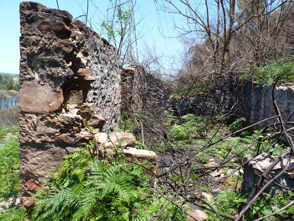
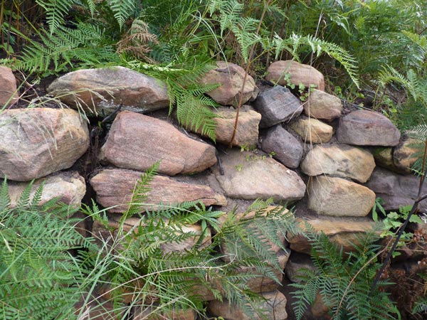
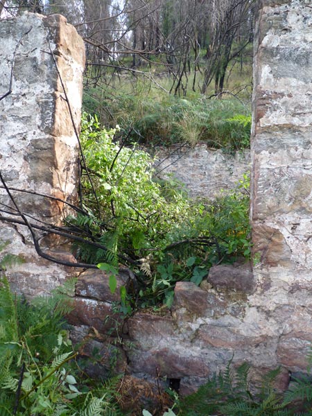
The ruins of what was known as ‘the white house’ are such an example. They comprise four, once white-washed walls, made of a composite, stone construction. The ruins are all that is now left of a two storey house built on the western side of the Nepean River, on the escarpment below Singles Ridge and directly opposite the Upper Castlereagh area. Although a modest, unpretentious structure, for many locals the white house became a familiar reference point on the escarpment. As well as highlighting its position in the bush landscape, the house’s whitish colouring seemed also to emphasize its lonely isolation.
[Arthur Street Collection – Penrith Library, NSW]The white house ruins remind me of William Wordsworth’s poem Michael which relates the sad story of an old shepherd. His shattered dreams for the future are symbolized by the ruins of what was to be a sheep-fold. In order to see this ‘straggling heap of unhewn stones’, it was necessary to leave ‘the public way’. The same is true for the white house which has always been a difficult and dangerous place to access. Crossing to the western bank was usually accomplished by fording the river at narrow, shallow sections or crossing by boat. The river’s susceptibility to flooding further isolated the area.
For many years I have lived within walking distance of the white house ruins, unaware of their existence. On hearing about the white house a year ago, my curiosity was roused to go in search of the ruins and their hidden history.
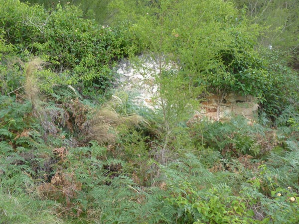
But finding the ruins was easier said than done. The thick covering of lantana, blackberry and other assorted weeds and thorny vines that greeted me in May last year (2013), made their finding difficult.
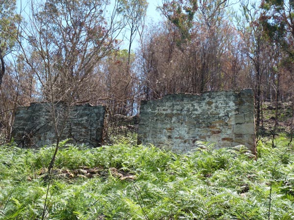
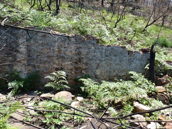
[White house ruins May 2013]No wonder I had previously walked past the area without seeing them. But despite the elation in finding the ruins, it was frustrating not to be able to access the site easily or to see the four surviving walls clearly. Later in October a severe bush fire raged through this and neighbouring parts of the Mountains. Returning in December, I found the ruined walls now clearly exposed in the blackened landscape.
[White house ruins December 2013 following the October bushfire]The definite worry of snakes made my time at the site limited and uneasy. However, I managed to document the ruins in photographs and video. I also planned to return before the bushland again accomplished another disappearing trick with the ruins.
From the arrival of Europeans to present times, the region where the white house ruins are appears to have been somewhat difficult to develop and manage. Originally part of the Colo Shire, since 2000 the area is now part of the 485 hectare Yellomundee Regional Park controlled by NSW National Parks and Wildlife Service.
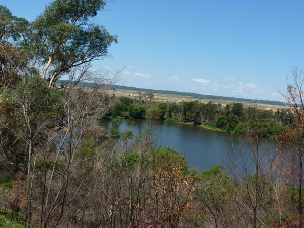
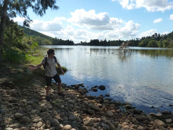
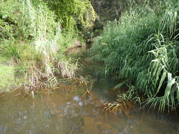
This area was first sighted by Europeans in late June 1789, the second year of their arrival in the colony they named New South Wales. Watkin Tench, a Captain Lieutenant in the marine corps, led a party from Rose Hill, exploring the land to the west. The group came upon an impressive river which Governor Phillip later named the Nepean. With considerable difficulty caused by the undergrowth, they followed it upstream. The capacity of this river to flood severely did not escape Tench’s attention. Despite being some 12 metres above the river level, he noted that there was still definite signs that the land had recently been flooded. He also saw plenty of evidence of indigenous life around the river, including huts, cut marks on trees, two canoes and some animal traps. In his account of this short, exploratory trip, Tench concluded that the country was a lonely, intimidating and unfamiliar place, full perhaps of hidden dangers.
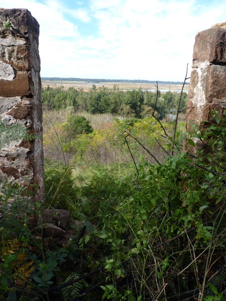
[view of the Nepean from the house ruins]Over the years, this description has remained appropriate to much of the country along the mountain escarpment on the western side of the river. I wondered what it must have been like to live in a place that was isolated, inconvenient to access, subject to the summer threat of bushfire and the vicissitudes of the Nepean River and lacking any of the utility services we now take for granted. Was it possible to develop a sense of belonging when living in such a place? I wanted to know more about the people who lived on the western side of the Nepean River and their lives there. The white house seemed the obvious place to begin looking for answers.
The Windsor and Richmond Gazette (2 July 1910) reported that in June 1910 Thomas Galvin and his wife Mercy (nee Selby) appealed against the unimproved, assessed value of their two adjoining properties (40 and 36 1/4 acres) fronting the western side of the Nepean River at Castlereagh. Galvin was a carpenter and builder. He was one of the first builders to work on St Stephen’s Church steeple at Newtown. Their 40 acre property happens to be the one where the white house ruins are.
Land value was based on the productivity and therefore profitability of each block. Galvin argued that there was a predominance of ‘rocks, gullies and mountains’ and insufficient grass land on both his blocks. Although the river flat could be cultivated, it was subject to flooding.
[remains of garden]In 1902 he had purchased the white house block for fifty pounds and had erected a house costing about 200 pounds. Three times he had rented the house, which he had furnished, along with ‘4 or 5 cows, horses and ploughs’. Galvin used the experiences of his three tenants to demonstrate the unprofitability of this block. Despite the initial rent of 7/- only increasing to 7/6, none of his tenants was able to see out the duration of their tenancy. Galvin’s appeal resulted in the assessed values being reduced on both blocks. The white house block was reduced from 160 to 100 pounds.
School teacher Arthur Street was appointed to Penrith Public School in May 1938. He said ‘in later years’ he became interested in the history of the Nepean Valley. ‘Now and again,’ he wrote, ‘something mysterious or intriguing would present itself. Such was The White House.’ When he first took students on an excursion there, ‘there were four walls left of a cottage, garden beds and some lime trees’. The walls ‘were painted white and visible for miles.’ The date of this excursion is not given. In 1967 his interest was roused again when he noticed ‘the disappearance of the familiar landmark’. Street asked his students if they knew anything about the building. He received a letter from student Peter Jackson’s grandfather, Cecil, who as a child had lived in the white house with his family. Despite renewing his interest and his subsequent retirement in 1973, Street apparently did not return to the white house ruins until early in 1984. This visit, with some members of his Local History Evening Class, resulted in his self-published booklet about the white house of the same year.
Included in Street’s booklet is Cecil Jackson’s informative letter about white house life, written in1967. The following account of life at the white house between 1916 and 1922 comes from information contained in that letter. I have also used information from interviews with Cecil’s sister Helene, also known as Nellie, and brother John, conducted by Street and also included in his booklet. Nellie’s married name was McManus and when interviewed she was living in Penrith. No date is given for the interview. However, it took place about 15 years after Street received Cecil’s letter, so that would date it in the early 1980s. On 16 May 1984 Street also interviewed John (Jack) Jackson who was living at Emu Plains. Born on 3 June, 1906, he was just about to turn 78.
[remains of dry stone garden retaining wall]The Jackson family moved to the white house in 1916, just after the start of the First World War. Incidentally, in the same year, the well known Australian landscape painter Elioth Gruner began a three year residence in a rented hut on James Innes’s farm. On this farm, a little further upstream at Emu Plains, Gruner painted a number of significant works, including Morning Light (1916) and Spring Frost (1919). These paintings portray a very beautiful, gloriously coloured and productive landscape.
The Jackson family had been living on a farm in Jackson’s Lane, Castlereagh. All the children were born there. The farm was opposite another farm where their grandparents lived. Nellie believed that both farms were rented. In 1916 their father rented Tom Galvin’s white house farm for five years. The family comprised John Thomas and Eva (nee Wright) Jackson, their four sons and three daughters.
From the outset, Cecil Jackson said that his family always referred to the building which they lived in on the farm as ‘the white house’. According to John the real name of the white house was Oakley.
The children ‘had a lot of hard work to do there’ but they also had ‘a lot of fun’. Jobs were done before and after school and on the week-end. These included milking the cows and feeding the calves. If there was insufficient grass for the cows and horses to eat, the children would climb and cut branches from the oak trees for feed. All the children helped with the collection of water from the river. They used a wooden yoke to carry the water in two kerosine tins. They also helped look after the vegetable garden. Some of the water collected was used on this garden. They grew tomatoes, cabbages and melons, as well as fruit trees. Their father also grew tobacco plants.
One of John’s jobs was to collect fire wood from the bush. Sometimes the girls collected the kindling. John was also responsible for locking the fowls up each night to protect them from foxes. Their father also set traps for dingoes.
Each Saturday morning Cecil remembered crossing the Nepean River with a horse and cart and travelling into Penrith to do the weekly shopping.
[Nepan River below the house looking north]When the river flooded, they had to head up to the ridge, and then walk into Springwood to purchase the weekly supplies. John remembered having to carry a bushel of wheat back from Springwood. ‘It was very heavy.’ Fishing and rabbiting augmented the family’s food supplies.
During most summer’s, fire-breaks had to be burnt around the house in preparation for any bush fires. ‘We always burnt the fire-breaks at night,’ Cecil recalled, ‘and really enjoyed doing it.’ Nellie recalled how the burning of the fire-breaks would ‘send the snakes amongst us and down to the river. Sometimes they would pass between our legs – they were so frightened.’ John remembered Tom Galvin sometimes coming to help the family defend the white house against the bush fires. According to John, he lived in the house below them.
[remains of back wall from inside the ruin]The children attended the local public school at Upper Castlereagh and were taught by Mr John Emery. ‘He was very strict,’ John recalled. ‘He would use the cane if you were naughty.’ They rowed their father’s boat across the river each day. When the river flooded, they stayed at home. If the river rose while they were at school, they would stay with their Aunt Nina at the end of Jackson’s Lane. For the last couple of years of their schooling, Nellie and John attended a small school at Single’s Ridge. Besides themselves, there were only three other students, all from the Butler family. Each day Nellie and John climbed a track behind the white house to reach the school. The river floods no longer interfered with their schooling.
The river obviously played a very important part in their daily lives. As well as contributing positively, it could also inconvenience their lives at the white house and also at times pose real danger. One year the river flooded greatly and drowned their sows and piglets. John recalled the time when their mother nearly drowned while crossing the river. It was around midnight and she was returning home after helping a sick relative at Castlereagh.
After the war, the world was again affected by another tragic, life threatening event in the form of the pneumonic influenza epidemic. Despite its geographic isolation, Australia was not spared the epidemic in 1919. And the isolated position of the white house provided no protection for the Jackson family either, their father soon catching the disease. However, their mother again showed her nursing ability, successfully restoring him back to health.
The family attended the Wesleyan Church at Upper Castlereagh every Sunday. John remembers his father being ‘very strict about church attendance.’
Leisure time pursuits included catching rabbits and sometimes snakes, swimming, mountain climbing, exploring caves and rolling rocks into gullies. They also enjoyed making boats and rafts to float on the river. There was no work on a Sunday after church, so a regular, weekend treat was a picnic in Field’s Gully, where Fitzgerald Creek flows into the Nepean. ‘It was lovely and cool in the summer time,’ Cecil remembered, ‘with a little stream trickling down the mountain and forming little clear pools from which we caught crayfish.’ Their mother would cook a fowl to take with them.
[Looking up Field’s Gully from the mouth of Fitzgerald Creek 2013]Their father, Cecil and John worked at Emu Gravel Pits towards the end of their time at the white house. They walked there and back each day. Before that Cecil and his father worked on an orchard at North Springwood. They camped there during the week, returning home on Friday night.
After five years living at the white house, the family rented a house owned by Sim Walker. Called Glenelg, it was situated on the Western Highway at Emu Plains. Cecil summed up the family’s five years at the white house by saying:
‘…we all had a happy and interesting life there, even though it was a bit out of the way.’ Nellie agreed: ‘We worked hard but we were happy.’ And according to John, they were all sad when the time came to leave the white house. ‘…It was a hard life and away from everyone else.’
In his letter Cecil made reference to the burning down of the white house during a bushfire ‘a few years ago’. He said that it left only the stone walls standing. A letter from Dorothy Dengate, dated 2 August 2001, was published in the Field Family Newsletter, 7th Edition. She recalled her childhood at Emu Plains and catching rabbits in Field’s Gully. She also inquired about a house near there which she thought possibly belonged to Edward Field. ‘The house was two stories (sic),’ she continued, ‘and had a veranda top and bottom, it was falling down then and we were never aloud (sic) to go into it. It would have been about 1940 – 43.’ It sounds like she was describing the white house. If that is so, the white house was still there but uninhabited. The Sydney Morning Herald’s front page on 8 December 1951 gave an account of a bushfire that destroyed homes on the Lower Blue Mountains. Under the headline ‘Nepean River Homes Threatened By Flames’, there is a photograph of a house that could possibly have been the white house. In the photograph, the fire front is very close to the house. I wonder if this was the fire to which Cecil was referring.
[SMH 8 Dec 1951]Arthur Street also interviewed Reginald Ernest Galvin, the grandson of Tom Galvin. The date of this interview is not given. Reginald’s parents were Ernest Victor Galvin and Myrtle Irene (nee Field). He was born in Sydney in 1917 and was an only child. His parents moved to live in the white house around 1922. He likened the place to a ‘hobby farm’, The fruit trees on the property included lemon, plum and apricot. He believed that the lemon trees were ‘wild ones’. They had fowls and a vegetable garden. His father owned a boat and a horse and cart. His father was employed in Sydney at a paint factory. Each week day he would ‘cross the river, pick up the milk-lorry into Penrith, then travel to Sydney by train’ and return in the evening.
In Street’s booklet there is a sketch of the white house compiled by Arthur Street, George Gyford and Jack (John) Jackson. Street refers to a ‘snap taken about 1920’ and also reproduced in the booklet. However, the quality of the reproduction is poor and does not assist in corroborating the sketch.
The sketch shows the white house to be a two storey building with a fibro room extension off the northern wall of the bottom room. This extension has a small front window and a fireplace, as there is a chimney, possibly of iron, at its side. The extension was more than likely used as the kitchen.
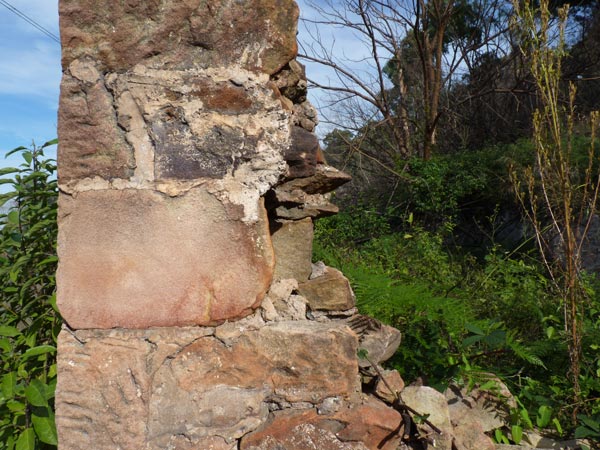
[remains of front wall looking in]The ruined walls that remain today appear to be those of the bottom room. The walls are a conglomerate of various sized pieces of sandstone, some of the outer walls and corners appearing to be dressed. The walls are around 35 centimetres thick. The stones are held together with a cement binding. On my first visit, I thought the break in the front wall was to accommodate a wide front door. On a recent visit (June 2014) I cut foliage away from the base of the wall and discovered there was another metre of stone wall before ground level. Now I am undecided as to whether there was a door filling this space or a window. If it was a door there may possibly have been steps up to it or there could have been a raised floor in front of it, perhaps a verandah. The later fits with Dorothy Dengate’s memory, referred to previously. But at the moment I am unsure.
[remains of front wall looking out]The building materials used in the second storey are uncertain, possibly being wood or fibro, or a combination of both. This storey has two front windows and a central door leading onto a verandah. The pitched roof could have been galvanized iron sheeting. It is still not clear if the second floor was part of the original building or a later addition. From a side elevation included in the sketch and a visit to the site itself, it can be seen that the house was positioned very close to the escarpment. Before building the house, a section of the escarpment slope would have been dug out and levelled. This would possibly have provided much of the stone used to build the walls of the bottom room. The close positioning of the back stone wall to the escarpment must have given easy, rear access to the second storey from the elevated backyard. A series of outside, stone steps descend to a side door into what I believe to have been the kitchen. This door is next to the chimney. This could mean that there was no internal access to the second floor, therefore losing no floor space. A pathway from the door near the kitchen leads across to the chicken coup and an outside toilet.
[stonework on northern wall]There is also another sketch of the house included in the booklet. This is a rough sketch drawn from the childhood memories by Reginald Galvin. In this sketch the chimney is attached to the north stone wall, there being no fibro extension in his drawing. The front stone wall appears to have only a small window and no front door. From my visits to the site, this is definitely not correct. Reginald Galvin was only a child of five when he came to live at the white house after the Jacksons departed. He did not say how long his family lived there. Perhaps his young age could account for some of his discrepancies.
Although grateful for all the wonderful information included in Arthur Street’s booklet, as the above inconsistencies in the sketches reveal, there are still many questions unanswered about the white house. There is uncertainty regarding the date when the white house was actually built. Reginald Galvin said that his grandfather bought the 20 acre property and home from Mr McCann. The fact that he said there was already a home on the land differs from Tom Galvin’s own evidence at the appeals court in 1910. There is also an error in Reginald’s recall of the actual size of the block. His grandfather stated that it was 40 acres in size and the Parish Map also shows this to be the case. After purchasing the land, Tom Galvin stated that he set about building a home on it.
No mention is made by him of any other dwelling on the block. And if there had been a house already there, was this the white house or a part of it? Or could it have been the smaller house Reginald drew to the right of the white house and closer to the river? Nellie Jackson remembered that house being there while her family resided at the white house. She referred to it as ‘the house down below’, however, she did not say whether it was occupied. Perhaps this was where Tom Galvin lived for a while, as remembered by John Jackson. It seems to have been only a temporary or weekend residence for Galvin. He had moved to Doonmore Street, Penrith in early 1920. In an article in the Nepean Times (27 March 1920), he complained about Doonmore Street’s inadequate lighting.
[causway crossing Fitzgerald Creek on route to the White House 2013]Early in 1931 Galvin left Penrith and moved to Marrickville. He was still the owner of the white house land in 1938. According to the Nepean Times (3 March 1938), part of Galvin’s river frontage was being considered for resumption as public recreation land because of a deep pool there. This part of the river was known then as Charlton’s Reach. It was seen as an ideal attraction for picnickers and swimmers, especially those from the nearby, new Staples Estate at Emu Plains. The idea never eventuated as the cost of making suitable road access to the site was deemed impractical.
A study of the white house highlights the importance of the Nepean River’s influence on life along its western bank. It provided a convenient source of water for domestic usage. It meant that families like the Jacksons could successfully supplement their food supply by growing vegetables and fruit trees, keeping animals and fishing. The river and its creeks also contributed to the quality of leisure time activities. However, the river had considerable, negative impacts on life there. Its regular flooding was life threatening, occasioned much inconvenience by isolating people and did untold damage to low lying land activity and property.
There was a definite sense of isolation and inconvenience experienced by those living on the western bank. But this seemed to assist in contributing towards the family members’ sense of reliance on each other and the responsibilities that entailed. Floods and bush fires further brought the family members closer as they sought to maintain a hard but happy existence.
[remains of wall with large crack indicating further deterioration ]Louisa Atkinson, acclaimed nineteenth century Australian botanist, artist and writer, once described the ruin of a house at Kurrajong as one ‘of the saddest kind, without antiquity, traditions, or grandeur’. For many people, that could be the way they view the white house ruin and its historical significance. However, I believe that this four, sandstone wall ruin is significant. It is one of the only surviving reminders in the landscape under Single’s Ridge that there ever was anyone living there. The hidden history of the white house, like some old jigsaw puzzle with countless pieces missing, needs to be researched to help us more fully understand the heritage of the local area. Our indebtedness to people like Arthur Street, who also appreciated this need, should not be under valued.
When I walk
I do not know
what ancient sacred place
my foot may desecrate
or if my tread shall fall
where some cult-hero bled,
or shed blood,
or gave fire to man
in the far dreamtime.

(from the poem Intruder by Ian Mudie)
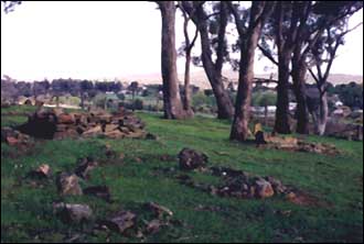
The cemetery occupies about an acre of land at Pennyweight Flat, on the outskirts of Castlemaine in central Victoria.
When gold was discovered in the 1850’s, it was to this region that most new arrivals in Melbourne headed. It soon became a very rich gold bearing area and was originally known as Forest Creek. Pennyweight Flat is adjacent to this famous gold field. The flat was so named because the diggings were not substantial there, the diggers claiming that the area was incapable of producing more than a pennyweight of gold for an acre worked. Thus the name Pennyweight and also the reason why a section of the flat was used for the site of a cemetery. In later years the cemetery was referred to as “God’s Acre”.
When Seweryn Korzelinski, a Polish gold seeker arrived at Forest Creek in December 1852, he optimistically wrote in his diary:
“Holes are to be seen everywhere, round ones and square ones, wide and narrow … It couldn’t be difficult or complicated to dig holes in the ground, bring the dirt to the surface and rock it in a cradle. After all, everyone of those miners we see around was a new chum once himself.”
Sentiments like these drew thousands of people to Forest Creek to seek their fortunes. Some brought their families with them.
But life on the diggings was hard, especially for little children. Between 1852 and 1857, nearly 200 children were buried in shallow graves at Pennyweight Flat Cemetery. Some of the reasons why so many children died include an inadequate water supply, poor diet, lack of sanitation, the spread of diseases like typhoid and whooping cough and the constant dangers of living in close proximity to deep holes.
When I first visited the cemetery one autumn morning in 1997, I was deeply moved by this place. The little rock piles which form the graves sit above the earth, the rock surface having been too hard for the shovels and picks to penetrate very deeply. As I wandered around reflecting upon this sacred place where sorrow was still present, a little girl came running into the cemetery ahead of her parents. In the short time I was aware of her presence, she had fallen over, burst into tears and run again. The distant sound of her crying mingled with the noise of a flock of magpies playing in the gum trees above.
 In the first few months of arrival in 1788, this island was briefly used to confine and punish wayward convicts. While there they had their rations limited to just bread and water. This explains the origin of the name Pinchgut when commonly referring to this small, rocky island.