BLUE TRAIL 58: OLD REHABILITATION PROJECT, State Mine Gully

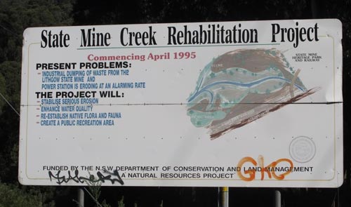
“If I wanted to get there, I wouldn’t start from here” is the punchline of an ancient joke about an Irishman giving directions to a tourist.  Almost as ancient are the laudable objectives on this signboard about the 1995 project which could yet be the jumping off point for the transformation of the southern Newnes Plateau into one of Australia’s finest and best presented natural area experiences – a project aptly named Destination Pagoda in its new incarnation (see article in Blue Mountains Conservation Society’s May Hut News,  page 2).  

pagodas in Gardens of Stone NP (Photos by Christine Davies)

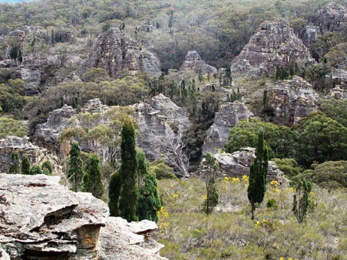
If you want to get to the finest views of pagodas in the Lithgow district, there’s no choice but to start from State Mine Gully.  On a school holiday Wednesday in April 2019, Hut News noticed steady traffic which included standard two-wheel-drive vehicles making their way up and down the shockingly deteriorated escarpment road that connects the Newnes Plateau with State Mine Gully.  Many of the drivers were protecting their vehicles by taking ten minutes to do one kilometre.  

The intended picnic area underlines the wild and non conforming mood of State Mine Gully. (Photos by Christine Davies)

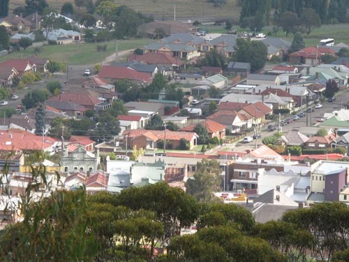
But this is the only viable access route for most of the plateau’s scenic delights that does not cross private property.  It is the only route that truly allows the community of Lithgow a sense of ownership of the most ecologically and geologically diverse part of the town’s hinterland.

A sign lists noble aims of a project which, due to lack of government spending, has fallen far short of its potential. (Photos by Christine Davies)

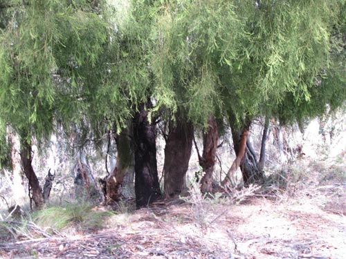
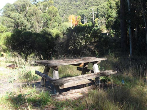
At the site of the old rehabilitation project, you are confronted with numerous expensive changes that would still need to be made to convince the visitor that this is one of Australia’s most significant natural area gateways.  The broom and blackberry plants, along with other weeds,   need to disappear.  The hardy Mountain Ash trees need their retinue of Banksia and Leptospermum understorey to swell.  The discarded sleepers and rails from the old branch line need to be incorporated into the generally well-kept railway museum.  And the picnic benches need to look capable of accommodating modern-sized posteriors without fracturing.  It’s fortunate that Destination Pagoda has harnessed such experienced and dedicated activists – all our energy will be needed.  

Broom plants and other weed species advance towards the Eucalypt forest at the Gardens of Stone gateway. (Photos by Christine Davies)

© Don Morison

Blue Trail 51: Collitts Inn, Hartley Vale

Collitts Inn, built in 1823, just two years after the departure of Lachlan Macquarie, is the oldest non-indigenous Australian structure west of the Blue Mountains. It serviced the road from Emu Ford on the Nepean River to the Bathurst Plains which descended from the location now known as Mount York lookout via the Coxs Road and then turned in a westward direction towards the location now known as Hartley Historic Village.

Some of the earliest colonial structures in NSW may never be surpassed for their aesthetics.   [photo: © Christine Davies]
In the same year it was built, 19 year old Archibald Bell Jnr was assisting his father to farm land near Bilpin and the young man befriended local indigenous people. Using his new friends’ guidance, young Archibald was able to follow a route past Mount Tomah to modern-day Bell, turn southward onto the ridge now known as Darling Causeway, and find the westward sloping gully that took him to Collitts Inn. Thus, he became the first non-indigenous person to prove that the Blue Mountains could be crossed by the route to be named “Bells Line of Road”.

An outbuilding of Collitts Inn is overshadowed by the sandstone promontory of Mount York.   [photo: © Christine Davies]
Pierce and Mary Collitts had been married in England in 1795 but in 1800 Pierce was convicted of receiving stolen goods and transported to New South Wales for 14 years, a sentence carried out with Pierce’s family accompanying him. He was to be effectively released in 1811. The family established themselves as respectable landholders in the Penrith, Prospect and Castlereagh areas before moving inland and building Collitts Inn. It was first known as the Golden Fleece, then the Royal Garter.

A modern day custodian of Collitts Inn is proud to be safeguarding a piece of history.   [photo: © Christine Davies]
Pierce and Mary had nine children. The most high profile was Amelia, subject of the musical play, “Collitts Inn”, written in the 1930s. This play chronicles the events that led to Amelia’s marriage to John Skeen. Amelia and John are the ancestors of numerous people who reside in the Blue Mountains today. William Collitts was regarded by Pierce as an “idiot son”. The tragic death of William’s young wife Caroline on the road near Mount Victoria was referred to in Blue Trail number 46.

Pierce, Mary and John Skeen are all buried in Hartley Vale cemetery, accessed off Fields Road, around the corner from the inn. Today, Collitts Inn is a wedding and function venue.

© Don Morison

Blue Trail 50:   Oberon Dam

Oberon Dam, built in two stages between 1943 and 1959 across the waterway now known as the Fish River, is 232 metres long and 35 metres high.  The surface area of the water it holds when full is 410 hectares.  It was originally built to supply water to the Glen Davis shale oil refinery and industries around Lithgow as well as the supporting population.  It now feeds water into areas served by the Sydney Catchment Authority, largely through a pipeline which conveys water to the base of the geological formation known as First Narrowneck, a short distance south of Katoomba township. 

The sparse native tree cover and the structures of Oberon dam are reflected in the captured waters of the Fish River [© Don Morison]
A short bushwalk off the Narrowneck fire trail allows you to hear the pumps working to lift the water from the floor of the Megalong Valley up into a system that lets it serve reservoirs in the upper mountains towns.  Until a few years ago, maintenance ladders known as “Dixons Ladders” paralleled the pipe rising against the cliff at Narrowneck.  Excessive adventurousness by some bushwalkers convinced the NPWS to remove the ladders.

The colours of deciduous exotics face a patch of Eucalypts on an autumn drive to Oberon dam. [© Don Morison]
A brief but pleasant drive takes the visitor from the Oberon Tourist Information Centre to the picnic area below the dam wall.  In autumn, the deciduous trees along the route offer a colourful display and there is a small patch of moderately disturbed natural bushland along the entry road.  You can walk along the dam wall but there is only limited access to the lake foreshores on either side.  This is one of several access points to the catchment lake which features in the popularity of the Oberon district for fishing.  

© Don Morison


Blue Trail 48: BRACEY’S LOOKOUT, Hassans Walls Plateau

The Hassans Walls Plateau, named by Governor Lachlan Macquarie in 1813 for its similarity to landforms in northern India, offers an eclectic selection of Blue Mountains scenery.

A curtain of Exocarpos cupressiformis (Native Cherry) on the slope north of the lookout [photo © Christine Davies]
In Hassans Walls (according to Col Bembrick in Coxs Road Dreaming 2015), we have a sandstone plateau rising above Permian deposits.  Many of the formations appear as outliers of the pagodas and other sandstone structures which characterise the Gardens of Stone district, one reason that Hassans Walls has been recommended to be included in Gardens of Stone reserved area Stage 2.

Pagodas, outliers of the many thousands of such formations found in existing reserved areas of the Gardens of Stone and proposed extensions.
[photo © Christine Davies]
Across the totality of Hassans Walls, there is evidence of major damage to surface features by now defunct underground coal mines but the area around Bracey’s Lookout (in the north-east of the plateau), is by no means the worst affected.  Bracey’s Lookout is connected to the Pottery Estate precinct within the Lithgow urban area by a steep foot track of only a few hundred metres but it is a dead end of more than two kilometres for motor vehicle access.  It is very popular with bushwalkers, dog walkers and cyclists.

The lookout offers one of the best overviews of the Lithgow urban area including the central business district, evoking memories of the Inch brothers, Pillans and the Bracey family themselves.

The section of Lithgow CBD containing the former Bracey’s Department Store, looking north from the lookout.
[photo © Christine Davies]
Horace and Alice Bracey arrived in Lithgow in 1886 and set up a retailing business in Excelsior Arcade.  Horace became Mayor in the 1890s and the business continued under his descendants, eventually ceasing trade in 2007 by which time it was operating in a substantial purpose-built department store in Main Street.  Generations of the Bracey family yielded some of the most outstanding philanthropists in Lithgow’s history, especially in meeting the cost of developing Hassans Walls for public recreation and appreciation of nature.

Inch Street (named after the founders of Lithgow Brewery), a north-eastern view from the lookout; a corner of Lake Pillans Reserve, named after another former mayor, is visible at the far right.
[photo © Christine Davies]

© Don Morison